


Okay, so I’m trying something new.
This first episode is free and available to everyone. Starting next week, this series becomes exclusive to Rough Riders - my $5/month subscribers.
Here’s why I’m doing it this way: I don’t believe in paywalling my actual investigations. The Neuralink reporting, the Larry Ellison series, everything I publish about power and surveillance - that stays free and accessible because information that matters shouldn’t be locked behind a subscription.
But I wanted to create something for the people supporting this work. Something that teaches you investigation techniques, breaks down the methodology, and shows you the craft behind the reporting.
So every Saturday, I’m going to walk you through one real investigation solved using open-source intelligence - OSINT. That means publicly available information. No classified documents, no inside sources. Just people analyzing what’s already out there.
Think of this as your Saturday morning detective hour - real cases that inspired me, real techniques you can learn and use.
This week:
Eliot Higgins proved Syria used chemical weapons from his apartment in England, using nothing but YouTube videos and Google Earth. The investigation that invented modern open-source investigative journalism and founded Bellingcat.
The Technique: Weapon Identification from Video
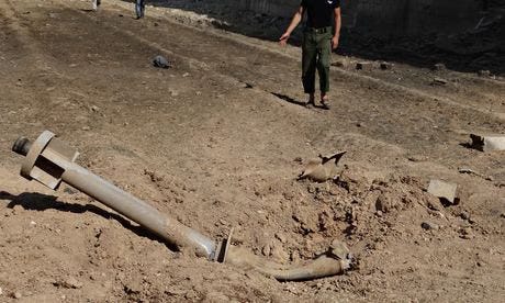
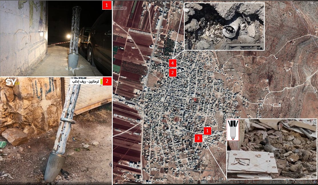
Higgins downloaded videos Syrian activists posted showing remnants of the rockets that delivered sarin gas. He screenshot individual frames, zoomed in on identifying features, and compared them to manufacturer specifications and military equipment databases he found online. This wasn’t guesswork - he systematically matched physical characteristics (size, shape, components, welding patterns) to known weapons systems until he could definitively identify them as improvised munitions only the Syrian military had capacity to build.
Why this matters: Video isn’t just documentation. It’s evidence. If you know what you’re looking at, a 30-second phone video can identify specific weapons, vehicles, or equipment that proves who was involved.
The Technique: Geolocation
Once Higgins identified the weapons, he needed to prove where they landed. He analyzed backgrounds in the videos - buildings, street layouts, architectural features - and then systematically searched Ghouta on Google Earth until he found streets that matched. He used Google Street View to verify angles and confirm the locations were accurate
The Technique: Trajectory Analysis
Here’s where it gets sophisticated. Higgins measured the angles of rockets visible in the wreckage. Because these large artillery rockets don’t fully disintegrate on impact, they leave evidence of the trajectory they came in on. By calculating backwards from multiple impact sites, he determined the general direction they were fired from - which pointed directly to Syrian government military bases in areas rebels had no access to.
Try This Yourself
Beginner Exercise: Basic Geolocation
Find any video filmed in a public location (protests, events, street scenes)
Pause on a frame with identifiable landmarks - buildings, signs, distinctive architecture
Open Google Maps and search the general area if you know it, or start searching based on clues
Use satellite view and Street View to try matching what you see in the video
See if you can pinpoint the exact location where the video was filmed
This is how you verify location claims. If someone says “this video shows X happening in Y location,” you can prove whether that’s true. (Now ofc it doesn’t tell you if the video is AI-generated - that’s a different skill for another Saturday). But it tells you if the claimed location matches reality. And once you can do that, you can start building timelines, cross-referencing multiple sources, and reconstructing what actually happened where.
Hope you enjoyed learning about this case as much as I did!
Tools & Resources
Bellingcat’s Original Syria Investigation: Bellingcat: The Missile Identification That Confirmed Assad Used Chemical Weapons
Google Earth Web: https://earth.google.com/web/ | Free satellite imagery and Street View access. Essential for geolocation.
Bellingcat’s Online Investigation Toolkit: https://bellingcat.gitbook.io/toolkit| Their guide to getting started with OSINT techniques.
Syria Archive: https://syrianarchive.org/ | Verified documentation of the Syrian conflict, including the Ghouta attack.
